Showing posts with label Research. Show all posts

The Technology Behind our Recent Improvements in Flood Forecasting

Flooding is the most common natural disaster on the planet, affecting the lives of hundreds of millions of people around the globe and causing around $10 billion in damages each year. Building on our work in previous years, earlier this week we announced some of our recent efforts to improve flood forecasting in India and Bangladesh, expanding coverage to more than 250 million people, and providing unprecedented lead time, accuracy and clarity.

To enable these breakthroughs, we have devised a new approach for inundation modeling, called a morphological inundation model, which combines physics-based modeling with machine learning (ML) to create more accurate and scalable inundation models in real-world settings. Additionally, our new alert-targeting model allows identifying areas at risk of flooding at unprecedented scale using end-to-end machine learning models and data that is publicly available globally. In this post, we also describe developments for the next generation of flood forecasting systems, called HydroNets (presented at ICLR AI for Earth Sciences and EGU this year), which is a new architecture specially built for hydrologic modeling across multiple basins, while still optimizing for accuracy at each location.

Forecasting Water Levels
The first step in a flood forecasting system is to identify whether a river is expected to flood. Hydrologic models (or gauge-to-gauge models) have long been used by governments and disaster management agencies to improve the accuracy and extend the lead time of their forecasts. These models receive inputs like precipitation or upstream gauge measurements of water level (i.e., the absolute elevation of the water above sea level) and output a forecast for the water level (or discharge) in the river at some time in the future.

The hydrologic model component of the flood forecasting system described in this week’s Keyword post doubled the lead time of flood alerts for areas covering more than 75 million people. These models not only increase lead time, but also provide unprecedented accuracy, achieving an R2 score of more than 99% across all basins we cover, and predicting the water level within a 15 cm error bound more than 90% of the time. Once a river is predicted to reach flood level, the next step in generating actionable warnings is to convert the river level forecast into a prediction for how the floodplain will be affected.

Morphological Inundation Modeling
In prior work, we developed high quality elevation maps based on satellite imagery, and ran physics-based models to simulate water flow across these digital terrains, which allowed warnings with unprecedented resolution and accuracy in data-scarce regions. In collaboration with our satellite partners, Airbus, Maxar and Planet, we have now expanded the elevation maps to cover hundreds of millions of square kilometers. However, in order to scale up the coverage to such a large area while still retaining high accuracy, we had to re-invent how we develop inundation models.

Inundation modeling estimates what areas will be flooded and how deep the water will be. This visualization conceptually shows how inundation could be simulated, how risk levels could be defined (represented by red and white colors), and how the model could be used to identify areas that should be warned (green dots).

Inundation modeling at scale suffers from three significant challenges. Due to the large areas involved and the resolution required for such models, they necessarily have high computational complexity. In addition, most global elevation maps don’t include riverbed bathymetry, which is important for accurate modeling. Finally, the errors in existing data, which may include gauge measurement errors, missing features in the elevation maps, and the like, need to be understood and corrected. Correcting such problems may require collecting additional high-quality data or fixing erroneous data manually, neither of which scale well.

Our new approach to inundation modeling, which we call a morphological model, addresses these issues by using several innovative tricks. Instead of modeling the complex behaviors of water flow in real time, we compute modifications to the morphology of the elevation map that allow one to simulate the inundation using simple physical principles, such as those describing hydrostatic systems.

First, we train a pure-ML model (devoid of physics-based information) to estimate the one-dimensional river profile from gauge measurements. The model takes as input the water level at a specific point on the river (the stream gauge) and outputs the river profile, which is the water level at all points in the river. We assume that if the gauge increases, the water level increases monotonically, i.e., the water level at other points in the river increases as well. We also assume that the absolute elevation of the river profile decreases downstream (i.e., the river flows downhill).

We then use this learned model and some heuristics to edit the elevation map to approximately “cancel out” the pressure gradient that would exist if that region were flooded. This new synthetic elevation map provides the foundation on which we model the flood behavior using a simple flood-fill algorithm. Finally, we match the resulting flooded map to the satellite-based flood extent with the original stream gauge measurement.

This approach abandons some of the realistic constraints of classical physics-based models, but in data scarce regions where existing methods currently struggle, its flexibility allows the model to automatically learn the correct bathymetry and fix various errors to which physics-based models are sensitive. This morphological model improves accuracy by 3%, which can significantly improve forecasts for large areas, while also allowing for much more rapid model development by reducing the need for manual modeling and correction.

Alert targeting
Many people reside in areas that are not covered by the morphological inundation models, yet access to accurate predictions are still urgently needed. To reach this population and to increase the impact of our flood forecasting models, we designed an end-to-end ML-based approach, using almost exclusively data that is globally publicly available, such as stream gauge measurements, public satellite imagery, and low resolution elevation maps. We train the model to use the data it is receiving to directly infer the inundation map in real time.
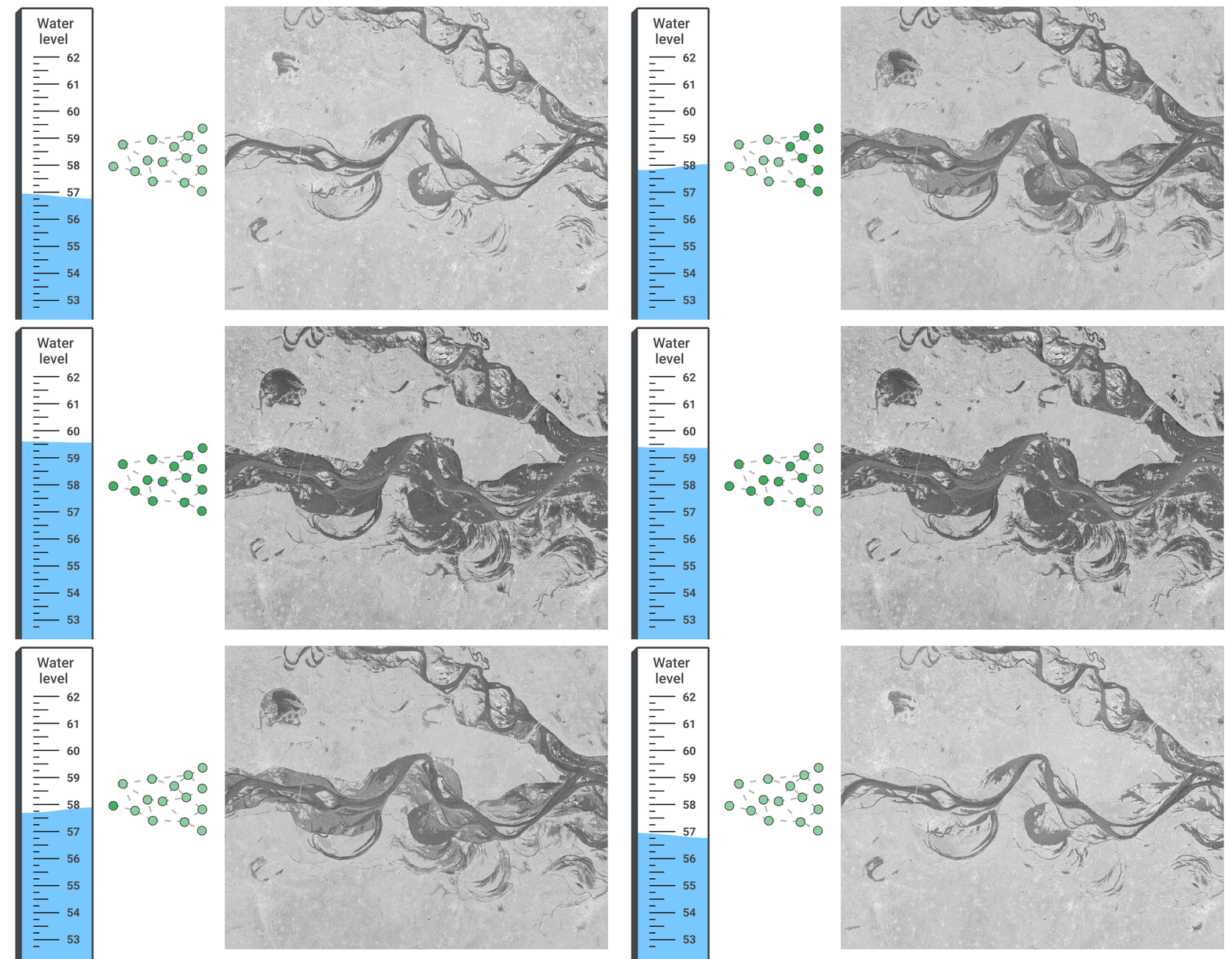
A direct ML approach from real-time measurements to inundation.

This approach works well “out of the box” when the model only needs to forecast an event that is within the range of events previously observed. Extrapolating to more extreme conditions is much more challenging. Nevertheless, proper use of existing elevation maps and real-time measurements can enable alerts that are more accurate than presently available for those in areas not covered by the more detailed morphological inundation models. Because this model is highly scalable, we were able to launch it across India after only a few months of work, and we hope to roll it out to many more countries soon.

Improving Water Levels Forecasting
In an effort to continue improving flood forecasting, we have developed HydroNets — a specialized deep neural network architecture built specifically for water levels forecasting — which allows us utilize some exciting recent advances in ML-based hydrology in a real-world operational setting. Two prominent features distinguish it from standard hydrologic models. First, it is able to differentiate between model components that generalize well between sites, such as the modeling of rainfall-runoff processes, and those that are specific to a given site, like the rating curve, which converts a predicted discharge volume into an expected water level. This enables the model to generalize well to different sites, while still fine-tuning its performance to each location. Second, HydroNets takes into account the structure of the river network being modeled, by training a large architecture that is actually a web of smaller neural networks, each representing a different location along the river. This allows neural networks that are modeling upstream sites to pass information encoded in embeddings to models of downstream sites, so that every model can know everything it needs without a drastic increase in parameters.

The animation below illustrates the structure and flow of information in HydroNets. The output from the modeling of upstream sub-basins is combined into a single representation of a given basin state. It is then processed by the shared model component, which is informed by all basins in the network, and passed on to the label prediction model, which calculates the water level (and the loss function). The output from this iteration of the network is then passed on to inform downstream models, and so on.

An illustration of the HydroNets architecture.

We’re incredibly excited about this progress, and are working hard on improving our systems further.

Acknowledgements
This work is a collaboration between the Google Flood Forecasting Initiative, the Google Geo and Crisis Response teams, Google.org and many other research teams at Google, and is part of our AI for Social Good efforts. We would also like to thank the Partnerships and Policy teams.
Tackling Open Challenges in Offline Reinforcement Learning

Over the past several years, there has been a surge of interest in reinforcement learning (RL) driven by its high-profile successes in game playing and robotic control. However, unlike supervised learning methods, which learn from massive datasets that are collected once and then reused, RL algorithms use a trial-and-error feedback loop that requires active interaction during learning, collecting data every time a new policy is learned. This approach is prohibitive in many real-world settings, such as healthcare, autonomous driving, and dialogue systems, where trial-and-error data collection can be costly, time consuming, or even irresponsible. Even for problems where some active data collection can be used, the requirement for interactive collection limits dataset size and diversity.

Offline RL (also called batch RL or fully off-policy RL) relies solely on a previously collected dataset without further interaction. It provides a way to utilize previously collected datasets — from previous RL experiments, from human demonstrations, and from hand-engineered exploration strategies — in order to automatically learn decision-making strategies. In principle, while off-policy RL algorithms can be used in the offline setting (fully off-policy), they are generally only successful when used with active environment interaction — without receiving this direct feedback, they often exhibit undesirable performance in practice. Consequently, while offline RL has enormous potential, that potential cannot be reached without resolving significant algorithmic challenges.

In “Offline Reinforcement Learning: Tutorial, Review, and Perspectives on Open Problems”, we provide a comprehensive tutorial on approaches for tackling the challenges of offline RL and discuss the many issues that remain. To address these issues, we have designed and released an open-source benchmarking framework, Datasets for Deep Data-Driven Reinforcement Learning (D4RL), as well as a new, simple, and highly effective offline RL algorithm, called conservative Q-learning (CQL).

Benchmarks for Offline RL
In order to understand the capabilities of current approaches and to guide future progress, it is first necessary to have effective benchmarks. A common choice in prior work was to simply use data generated by a successful online RL run. However, while simple, this data collection approach is artificial because it involves training an online RL agent which is prohibitive in many real-world settings as we discussed previously. One wishes to learn a policy that is better than the current best from diverse data sources that provides good coverage of the task. For example, one might have data collected from a hand-designed controller of a robot arm, and use offline RL to train an improved controller. To enable progress in this field under realistic settings, one needs a benchmark suite that accurately reflects these settings, while being simple and accessible enough to enable rapid experimentation.

D4RL provides standardized environments, datasets and evaluation protocols, as well as reference scores for recent algorithms to help accomplish this. This is a “batteries-included” resource, making it ideal for anyone to jump in and get started with minimal fuss.

Environments in D4RL

The key design goal for D4RL was to develop tasks that reflect both real-world dataset challenges as well as real-world applications. Previous datasets used data collected either from random agents or agents trained with RL. Instead, by thinking through potential applications in autonomous driving, robotics, and other domains, we considered how real-world applications of offline RL might require handling of data generated from human demonstrations or hard-coded controllers, data collected from heterogeneous sources, and data collected by agents with a variety of different goals.

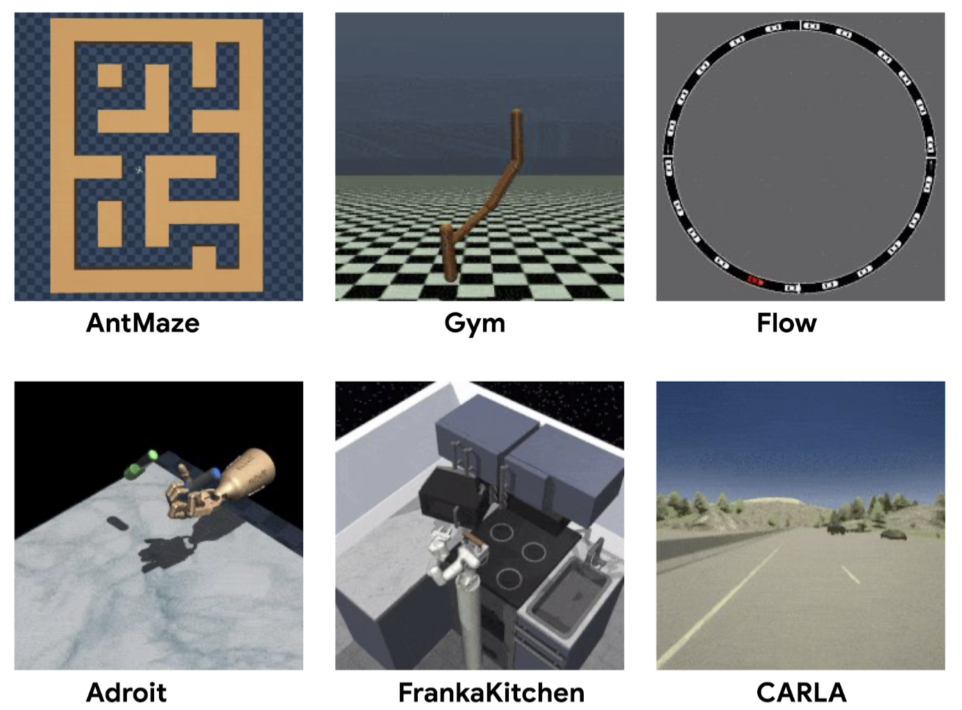
Aside from the widely used MuJoCo locomotion tasks, D4RL includes datasets for more complex tasks. The Adroit domain, which requires manipulating a realistic robotic hand to use a hammer, for example, illustrates the challenges of working with limited human demonstrations, without which these tasks are extremely challenging. Previous work found that existing datasets could not distinguish between competing methods, whereas the Adroit domain reveals clear deficiencies between them.

Another common scenario for real-world tasks is one in which the dataset used for training is collected from agents performing a wide range of other activities that are related to, but not specifically targeted towards, the task of interest. For example, data from human drivers may illustrate how to drive a car well, but do not necessarily show how to reach a specific desired destination. In this case, one might like offline RL methods to “stitch” together parts of routes in the driving dataset to accomplish a task that was not actually seen in the data (i.e., navigation). As an illustrative example, given paths labeled “A” and “B” in the picture below, offline RL should be able to “remix” them to produce path C.

Having only observed paths A and B, they can be combined to form a shortest path (C).

We constructed a series of increasingly difficult tasks to exercise this “stitching” ability. The maze environments, shown below, require two robots (a simple ball or an “Ant” robot) to navigate to locations in a series of mazes.

Maze navigation environments in D4RL, which require “stitching” parts of paths to accomplish new navigational goals that were not seen in the dataset.

A more complex “stitching” scenario is provided by the Franka kitchen domain (based on the Adept environment), where demonstrations from humans using a VR interface comprise a multi-task dataset, and offline RL methods must again “remix” this data.

The “Franka kitchen” domain requires using data from human demonstrators performing a variety of different tasks in a simulated kitchen.

Finally, D4RL includes two tasks that are meant to more accurately reflect potential realistic applications of offline RL, both based on existing driving simulators. One is a first-person driving dataset that utilizes the widely used CARLA simulator developed at Intel, which provides photo-realistic images in realistic driving domains, and the other is a dataset from the Flow traffic control simulator (from UC Berkeley), which requires controlling autonomous vehicles to facilitate effective traffic flow.

D4RL includes datasets based on existing realistic simulators for driving with CARLA (left) and traffic management with Flow (right).

We have packaged these tasks and standardized datasets into an easy-to-use Python package to accelerate research. Furthermore, we provide benchmark numbers for all tasks using relevant prior methods (BC, SAC, BEAR, BRAC, AWR, BCQ), in order to baseline new approaches. We are not the first to propose a benchmark for offline RL: a number of prior works have proposed simple datasets based on running RL algorithms, and several more recent works have proposed datasets with image observations and other features. However, we believe that the more realistic dataset composition in D4RL makes it an effective way to drive progress in the field.

An Improved Algorithm for Offline RL
As we developed the benchmark tasks, we found that existing methods could not solve the more challenging tasks. The central challenge arises from a distributional shift: in order to improve over the historical data, offline RL algorithms must learn to make decisions that differ from the decisions taken in the dataset. However, this can lead to problems when the consequences of a seemingly good decision cannot be deduced from the data — if no agent has taken this particular turn in the maze, how does one know if it leads to the goal or not? Without handling this distributional shift problem, offline RL methods can extrapolate erroneously, making over-optimistic conclusions about the outcomes of rarely seen actions. Contrast this with the online setting, where reward bonuses modeled after curiosity and surprise optimistically bias the agent to explore all potentially rewarding paths. Because the agent receives interactive feedback, if the action turns out to be unrewarding, then it can simply avoid the path in the future.

To address this, we developed conservative Q-learning (CQL), an offline RL algorithm designed to guard against overestimation while avoiding explicit construction of a separate behavior model and without using importance weights. While standard Q-learning (and actor-critic) methods bootstrap from previous estimates, CQL is unique in that it is fundamentally a pessimistic algorithm: it assumes that if a good outcome was not seen for a given action, that action is likely to not be a good one. The central idea of CQL is to learn a lower bound on the policy’s expected return (called the Q-function), instead of learning to approximate the expected return. If we then optimize our policy under this conservative Q-function, we can be confident that its value is no lower than this estimate, preventing errors from overestimation.

We found that CQL attains state-of-the-art results on many of the harder D4RL tasks: CQL outperformed other approaches on the AntMaze, Kitchen tasks, and 6 out of 8 Adroit tasks. In particular, on the AntMaze tasks, which require navigating through a maze with an “Ant” robot, CQL is often the only algorithm that is able to learn non-trivial policies. CQL also performs well on other tasks, including Atari games. On the Atari tasks from Agarwal et al., CQL outperforms prior methods when data is limited (“1%” dataset). Moreover, CQL is simple to implement on top of existing algorithms (e.g., QR-DQN and SAC), without training additional neural networks.

Performance of CQL on Atari games with the 1% dataset from Agarwal et al.

Future Thoughts
We are excited about the fast-moving field of offline RL. While we took a first step towards a standard benchmark, there is clearly still room for improvement. We expect that as algorithms improve, we will need to reevaluate the tasks in the benchmark and develop more challenging tasks. We look forward to working with the community to evolve the benchmark and evaluation protocols. Together, we can bring the rich promises of offline RL to real-world applications.

Acknowledgements
This work was carried out in collaboration with UC Berkeley PhD students Aviral Kumar, Justin Fu, and Aurick Zhou, with contributions from Ofir Nachum from Google Research.